Projects

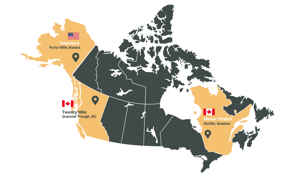
J2 Metals Map of all projects

Twenty Mile

Location: British Columbia, Canada
Size: 9500 Ha
Stage: Early
Deposit Type(s): Porphyry Cu / Epithermal Au
J2 Interest: 100%

Overview

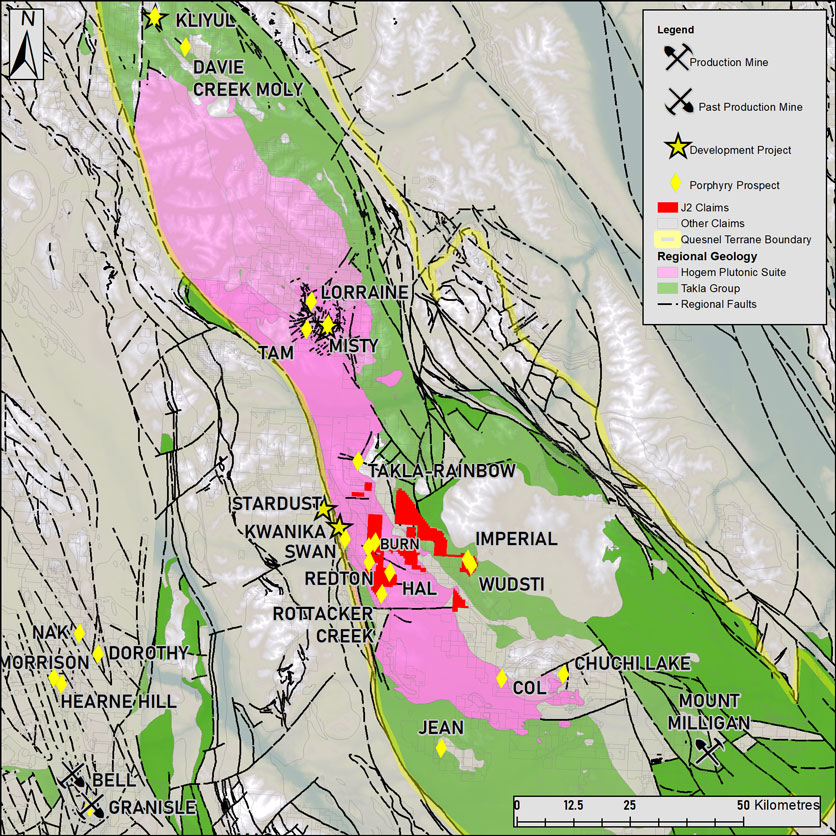
The Twenty Mile (TM) Project is located in BC’s Prolific Quesnel Trough Porphyry Belt, host to world class porphyry deposits such as Highland Valley Copper (Teck), Copper Mountain (CMMC), Mt Polley (Imperial Metals), New Afton (New Gold), and Mount Milligan (Centerra). The area around TM is surrounded by advanced development projects such as Northwest Copper’s Kwanika/Stardust and Lorraine projects, Pacific Ridge’s Kliyul Project as well as a host of Alkalic Cu-Au targets.
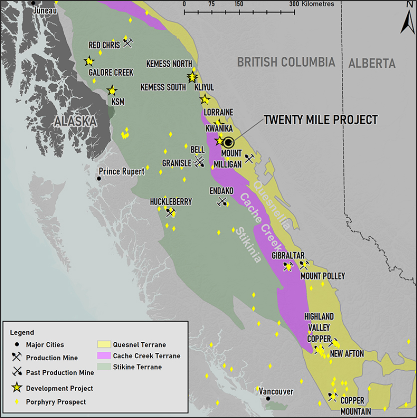
Twenty Mile Location within the Quesnel Trough

Fig 1: Twenty Mile Location within the Quesnel Trough

Location and Access

Located approximately 220km from Prince George and 80km Northwest of Mount Milligan, Twenty Mile can be accessed by vehicle through a network of well-maintained gravel logging roads.

The TM Project consists of 5 distinct claim blocks ranging in size from 255Ha to 9823Ha. The overall property is accessed by a network of nearby logging roads which have recently expanded. There is an active logging road that reaches the Burn Block as well as an ATV trail that transects its northern extent., The TM, Groundhog and Smoke blocks have no infrastructure and must be accessed by foot or Helicopter. The Wud Block can be reached via a decommissioned logging road.

Twenty Mile Regional Geology with Porphyry Minfile Showings
Fig 2: Twenty Mile Regional Geology with Porphyry Minfile Showings

Geology and Mineralization

The Quesnel terrane is a Mesozoic arc complex that stretches the length of the province and contains numerous late Triassic to Early Jurassic calc-alkaline and alkaline intrusions hosting Cu-Au-Mo-Ag porphyry deposits. The region around TM is characterized by Takla Group Volcanics overlain by the Chuchi lake and Twin Creek successions. These are intruded by various phases of the Hogem Batholith. The terrane is bound by the Pinchi Fault to the West and the Manson-McLeod fault to the east with many cross structures marking a complex structural environment for porphyry emplacement.

The entire region is masked by glacial overburden which has complicated exploration campaigns of the past. This is more apparent in many of the lower elevation areas of the region in which TM is largely located.

Exploration History

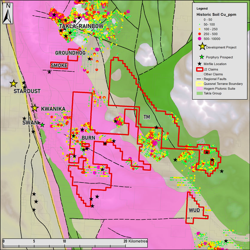
Exploration in the area east of Kwanika has consisted mostly of traditional soil geochemistry and some geophysics. Past soil grids covered various areas of the TM claims and were conducted by The Luc Syndicate (1971) Imperial Metals (1986), Westin Resources (1986, 1991,1992), Placer Dome (1990) and Kiska Metals (2011-12). A large area of copper and gold anomalous soil results occur near the Wudsti and Imperial Minfile showings on and near the TM and Wud claim blocks. This area has also had past production of coarse grain placer gold in nearby creeks.

The Burn showing was drilled by Placer Development in 1972, 1976 and 1979 for its molybdenum content and no significant copper grades were found. This despite copper in soil anomalies up to 4000ppm or 0.4% Cu abover the drilling area and noted chalcopyrite in outcrop maps to the west.

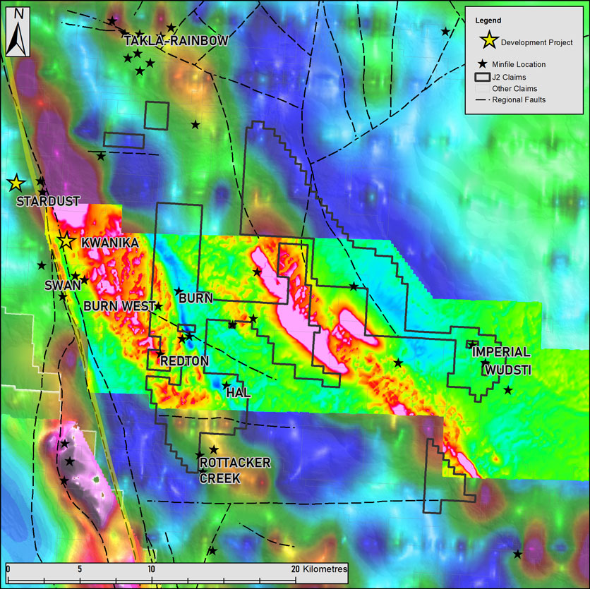
A 2010 aerial magnetic survey was conducted in 2010 by Kiska/Pacific Ridge over the Redton property, a portion of which covers the Burn block. A large magnetic-radiometric survey was also conducted by Natural Resources Canada in 2005 that covered most of the region and included the KW, Burn, Redton and a large portion of the TM claim blocks.

Historic Soil Geochemistry and TM Claim Blocks
Fig 3: Historic Soil Geochemistry and TM Claim Blocks

1VD Regional Magnetics.
Fig 4: TMI Regional Magnetics

2022 Plans

J2 conducted a large-scale reconnaissance MMI Sampling program over the TM property during the summer of 2022. Results are pending. We have also begun permitting for IP geophysics over the Burn and Wud blocks with an aim to drill select targets in 2023.

Napoleon

Location: Alaska, USA
Size: 5,925 ha.
Stage: Early
Deposit Type(s): Orogenic Au /
Intrusion related Au
J2 Interest: 100%

PDF  Technical Presentation

Overview

The Napoleon Project lies in the heart of the Tintina Gold Province, a region spanning 2000 kilometres that has produced more than 30 million ounces of gold 1

Napoleon is located in the Fortymile Region of Eastern Alaska, which has produced an estimated 500,000 oz of placer gold 2. Despite this extensive placer production, no major hard rock or “lode gold” production has been documented in the district.

J2’s exploration focus, led by Technical Partner Kenorland Minerals, is testing the Napoleon Creek Intrusive, the most significant intrusive gold system in the region as a possible source for the coarse grain placer gold that is found in all drainages surrounding the property.
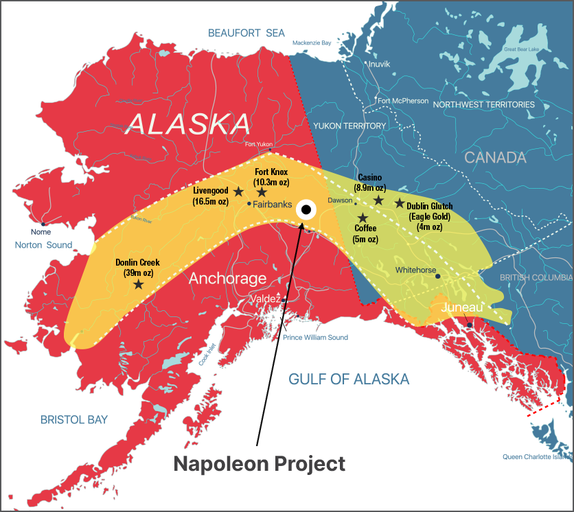
The Tintina Gold Belt has yielded an estimated 30 million ounces of gold. Numerous projects and production mines throughout the belt have Au gross metal contents from current resource estimates that total more than 80 million ounces of gold (Source).

Location and Access

The Napoleon project covers 5925 hectares of state-owned Alaska mining claims. It is located 15km northeast of the town of Chicken or 140 km from the town of Tok along the seasonal Taylor Highway. The property is accessed via a network of four-wheel-drive trails which follow the ridge tops throughout much of the project area.

Napoleon Property and 40mile placer creeks.

Napoleon exploration camp, September 2021

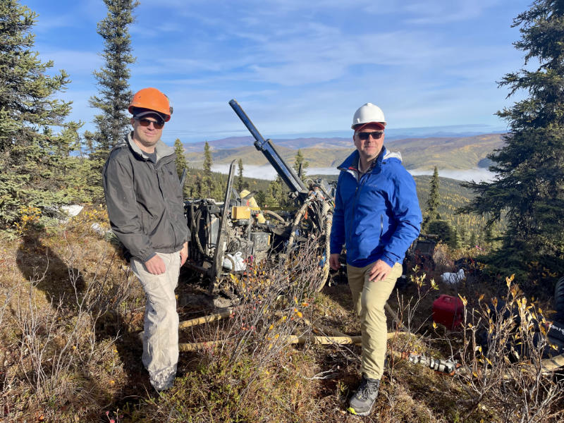
Graham Giles, VP Exploration and Thomas Lamb, CEO

Geology and Mineralization

The property is located within Alaska’s historic Forty Mile Mining District, which is part of the prolific Tintina Gold Province. The Tintina hosts significant deposits such as Donlin Creek, Fort Knox, Pogo, Livengood, Coffee Brewery Creek and Dublin Gulch. Gold mineralization at Napoleon is related to a regional shear zone which intersects the Jurassic aged Napoleon pluton. Gold mineralization is controlled by east-west and northwest trending structures and are commonly kaolinite-quartz-carbonate altered. High-grade gold is associated with quartz-pyrite veins, with K-feldspar-sericite-pyrite altered selvedges.

Exploration History

Kennecott first staked the property in 1998 following regional compilation work that identified anomalous gold-in-stream-sediment samples reported by Phillips Petroleum in 1982. Kennecott carried out soil sampling over areas of known mineralization as well as stream sampling throughout the property. During the 1998 and 1999 field seasons, soil geochemistry and trenching led to the discovery of five target areas: Main Zone, Saddle Zone, Trench 24, Twin Peaks and Burnt Ridge. Kennecott subsequently drilled 6 diamond drill holes and 10 RC holes with highlights including 0.61m @ 38.26 g/t Au in hole NAP-3 and 9.2m of 1.8g/t Au in hole NRC4.

Teck Resources explored the Napoleon property between 2000 and 2001. Exploration included ground magnetic and induced polarization geophysical surveys, and additional soil sampling. This work was subsequently followed up with 11 diamond drill holes, returning 74m of 0.9g/t including 0.90m of 22.7 g/t Au in NP-10 and 3.0m @ 8.9 g/t Au at the Saddle Zone in hole NP2.

A total of 4759 meters over 27 holes were drilled by Kennecott and Teck resources. Average hole depth was 166m

Between 2007 and 2009 Millrock Resources Inc. conducted additional soil and rock sampling along with a review and evaluation of existing data to generate additional drill targets. Millrock did not conduct any drilling on the property and the ground was eventually relinquished.

Northway Resources Corp. iNorthway) acquired the Napoleon property in 2019. Exploration activities conducted by Northway in 2020 included a ground-based magnetometer and very low frequency electromagnetic (VLF-EM) survey and infill C-horizon soil sampling over the main target areas to help define drill ready targets.

Miniac

Location: Quebec, Canada
Size:
Stage: Early
Deposit Type(s): Volcanogenic Massive Sulfide (VMS), Intrusion related Au
J2 Interest: 100%

Overview

The Miniac Project is a VMS target located in the Northern Abitibi Volcanic zone, part of the Abitibi Greenstone Belt, one of the largest gold endowed districts in the world. Located between the past producing Normetal mine and the Osborne-Bell mine along the Chicobi fault system, Miniac is an exhalative polymetallic system consisting of Au, Ag, Cu and Zn massive sulphides along a felsic-mafic volcanic contact.
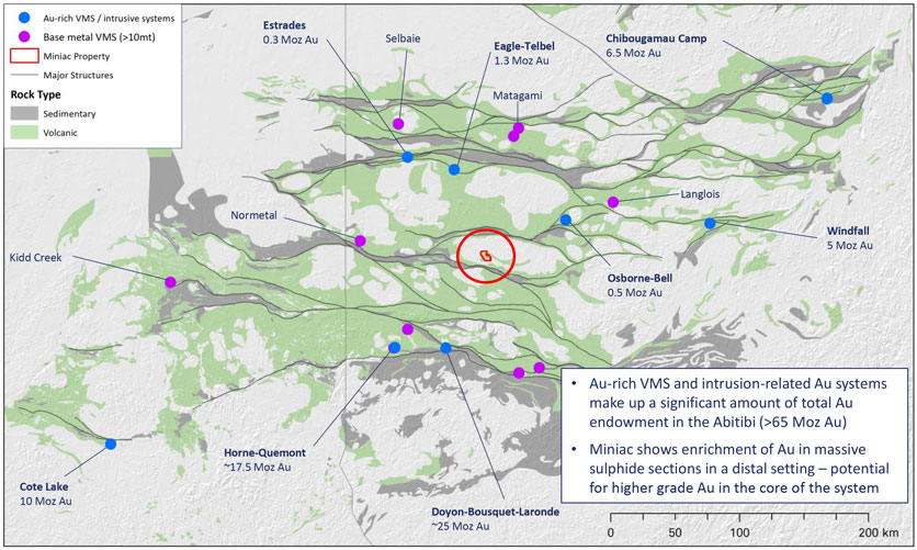
Location within the Abitibi Region with known Metal Endowment (Source).

Location and Access

The Miniac Project is located approximately 30km North of the town of Amos, Quebec. It is easily accessed by an extensive network of gravel logging roads across the entire claim package. A power line is 7 km away.

Geology and Mineralization

Miniac is located in the North Volcanic Zone of the Abitibi Greenstone Belt. Geology on the property consists of a mix of mafic to intermediate volcanic and ash tuffs as well as granitic units. Outcrop exposure is poor and the property is covered in glaciolacustrine clays.

Widespread anomalous Au-Ag-Zn-Cu mineralization has been intersected across a 4km strike length at Miniac. Mineralization is interpreted as sulphide facies exhalative horizons composed of pyrrhotite-pyrite +/- chalcopyrite and sphalerite. There is possible Au enrichment from an interpreted NNW trending splay structure off the Chicobi deformation zone. The massive sulphide horizon lines up well with conductivity geophysics.

Historical Drilling

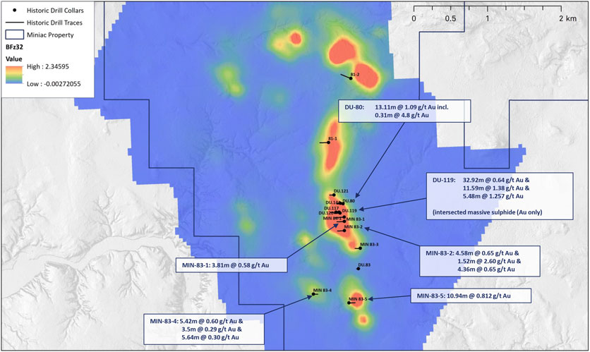
Historic drilling has targeted EM anomalies over a 2km by 4km strike length.

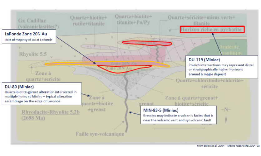
Highlighted historic drill intercepts include 4.80 g/t Au over 0.60 m and 4.80 g/t Au, 6.88 % Zn and 1.05% Pb over 0.30 m (DDH DV-80) and 1.37 g/t Au over 4.00 m, 2.06 g/t Au over 5.50m and 1.71 g/t Au over 2.40 m (DDH DV-119). Drilling to test VTEM anomalies in 2020 yielded 1.05g/t Au and 0.16% Zn over 4.65m in drillhole 20MDD004.

Drilling at Miniac has intersected alteration and geologic features comparable to distal features at the LaRonde Au VMS deposit. This suggests good exploration potential at depth.